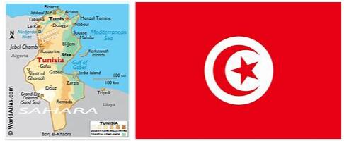
Only 19% of the land is arable, although 13% of it is irrigated (est. 1993). As a country located in Africa according to EHEALTHFACTS, Tunisia is the smallest country of the Northwest African states and ranks 89th on the list of the largest countries on the planet. It has a total area of 164,418 km². Of this area, 155,360 km², that is, 94.5% of the total area, are terrestrial. The rest, 9,058 km², 5.5%, are aquatic. The highest point in Tunisia is Mount Jebel Chambi, north of the city of Kasserine, and is 1,544 meters above sea level. The surface of the mount is covered with pine trees. Tunisia has 965 km of borders with Algeria and 459 km of borders with Libya. In addition, it has a 1,148 km long coastline. However, its coastline is full of small islands. Between Sicily and Tunisia there is a distance of only 130 km through the Sicilian channel. The elephants, Hannibal immortalized by the use in their battles have become extinct in Tunisia. Lions also disappeared centuries ago, used by the Romans in their shows. French settlers nearly drove the Barbary deer and some species of gazelle to extinction.
Borders
Starting from the North and going towards the South, in the first place there are a series of mountain ranges, among them the Atlas Mountains, in the so-called Tell region, which occupy the northern half of the country and cross the Tunisian territory transversely from the southwest to northeast, with heights ranging between 610 and 1,544 meters above sea level, reaching the highest point of this mountain range, the so-called Ech Chambi de Jebel, which in turn is the highest point in Tunisia.
In these territories fertile valleys and plateaus meet with mountains. This area is where the longest river in Tunisia, the Majardah or Medjerda, is born, 460 km long, which crosses the area from west to east and then reaches the Gulf of Tunis, where it empties.
Towards the South, the landscape changes the mountains for a plateau with an average height of 610 meters above sea level. These plateaus gradually descend to an area formed by salty lakes, known as shatts or chotts, which extend from east to west and are mostly at sea level. Among these lakes we can highlight the Djerid and the Bizerte. This area is characterized by its semi-desert steppe nature.
In the southernmost area, the shatts join the Sahara desert, which occupies 40% of the total area of Tunisia. In the area between the shatts and the Sahara desert there are numerous oases; especially in the vicinity of the city of Gabes, located in the center of the homonymous Gulf of Gabes that receives the same name, in the area closest to the border with Libya. In this region, vast oases abound, with nearly 400,000 date palms growing there. The oases are also used as a field for cultivation; these crops partly reach the coast.
To the north, Tunisia borders Algeria and describes a border that is defined by the irregularities of the terrain in the Atlas Mountains, with the exception of the northernmost area in which the border is defined by the Algerian natural park of El Kala. These natural limes occur along the entire mountain system that runs through Tunisia, but when that system descends and the Sahara desert appears, more specifically, the Greater Eastern Erg, the border with Algeria becomes a simple straight line, since it does not There is no geographical feature in that territory capable of shaping a border.
Relief
The Tunisian relief is based on the Tellian Atlas in the north and the Atlas Mountains in the center of the country. In southern Tunisia a semi-desert steppe extends to later become the Sahara desert.
The highest point in the country, the Ech Chambi de Jebel, is located in its center, in the Atlas Mountains, and measures 1,544 meters above sea level. Around this peak lies the Jebel Chambi Natural Park. In turn, the lowest point is Shatt Al Gharsah, in the southwest of the country, on the border with Algeria, and is 17 m below sea level. Very close to this shatt is the El Jerid shatt, the largest in Tunisia.
Between the cities of Bizerte and Tabarka there is an extension of the Atlas called the Dorsale mountain range, where cultivated fields abound. This region produces most of the country’s food and exports many types of crops, such as olives or citrus. In the relief of central and northern Tunisia, the large mountainous regions of the Atlas Mountains alternate with depressions generated by some rivers or shatts.
Tunisia has many natural parks among its mountains, such as Jebel Chambi, where the highest point in the country is located, Jebel Bu Hedma, Ichkeul National Park or Bu Kornine Park.