Geography
Libya, an essentially Saharan country, and with an elevation between 200 and 600 m. Located in North Africa, between the coordinates 25 00 of North Latitude and 17 00 of East Longitude, Libya is one of the largest countries in Africa, occupying the fourth place with an area of 1,775,000 km2 and the 15th place at the level world. It is bordered to the north by the Mediterranean Sea, to the east by Egypt and Sudan, to the south by Chad and Niger and to the west by Algeria and Tunisia. Its capital is Tripoli.
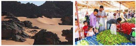
Its most important natural features are the Mediterranean coast and the Sahara Desert. With an average elevation of between 200 and 600 meters, the country has several mountains that do not become true mountain ranges, except in the southern region, near the border with Chad, where it rises to more than 2,200 meters. Tibesti massif, a group of non-active volcanoes that form a mountain range. The Tibesti mountains are the largest and highest in the Sahara.
Because the desert, stony plains and sandy seas occupy about 95% of Libya’s surface, a relatively narrow coastal strip and some southern regions are the most productive agricultural areas.
Climate
In Libya you can find five different climatic zones, but the greatest influence is the strip of the Mediterranean coast with dry summers and relatively humid winters and the pre-desert and desert conditions towards the south as it enters the Sahara, with high temperatures during the day that are significantly reduced at night.
Less than 2% of the Libyan territory receives enough rainfall to practice agriculture, with the highest rainfall occurring in the Jabal al Akhdar area of Cyrenaica with up to 600 millimeters per year. Rainfall is often erratic, with long intervals of time between one rainy season and another. In 1987, the government of Muammar Gaddafi, taking into account the scarcity of water resources, took measures to save water and built a series of dams in boulevards, which at the same time allowed the storage of water, controlled floods and the erosion.
Vegetation
Most of the surface of Libya is devoid of natural vegetation or appears only sparsely. Date palms grow in the scattered oases, as well as olive and orange trees, and junipers and mastic trees are found in the raised areas.
Fauna
Among the wild animals, desert rodents such as hyenas, gazelles and wildcats stand out. Eagles, hawks, and vultures are also common.
Economy
Libya’s economy is based on oil, which makes up almost all of its exports (95%). Libya has belonged to OPEC since its founding. It is the most important source of income, 50% of state revenues and 25% of GDP. There is also an industry related to oil and refining, energy, consumer goods, cement and textiles.
Libya’s economy is the sixth in Africa, after those of South Africa, Nigeria, Egypt, Algeria and Morocco.
The Libyan Dinar is the currency unit of the country. The Central Bank of Libya, is the issuing bank of the nation, regulates credits and supervises the financial system.
Engineering
In Libya, the Great Artificial River is being built, one of the largest and most expensive engineering projects (about 24,000 million dollars) of humanity. It includes the installation of huge pipes to transport the water from the fossil aquifers of the Sahara (underground natural deposits from when the desert was a fertile savannah and forests) from the south of the country to the coast, where the population is concentrated.
In the Kufra region, in the south of the country, there is an important water and irrigation project that aims to develop vegetable crops in the desert. Irrigation is done with groundwater, since rainfall in the region is practically non-existent. Irrigation is carried out through the radial system. The Kufra oasis is one of the human creations that can best be seen from space. Each circle is about 1 km in diameter.
Farming
Libya’s arable land is located in the north, in the Tripolitania region. 15% of the Libyan workforce works in agriculture. The main crops in Libya are:
- Cereals (215,000 Tons)
- Fruits (385,000 Tons)
- Vegetables (850,000 Tons)
- Oilseeds (45,000 Tons)
Only 1.2% of the Libyan Territory is cultivated land, 0.2% permanently, having to import 75% of the food consumed in the country.
Natural resources
As a country located in Africa according to INTERNETSAILORS, Libya’s main natural resource is oil. They also exploit natural gas, gypsum, iron, limestone, sea salt and potassium.
Sightseeing
One of Libya’s sources of income is tourism. The warm climate of the coastal areas and the Roman and Greek ruins are an attractive potential for the development of tourism. Among its great Archaeological treasures is the so-called “White Bride of the Mediterranean”, it is the name that formerly received Tripoli. Among his most important works of tourist interest are: the Souk of al-Mushir, The Clock Tower, the Arch of Marcus Aurelius, the Sabrantha Theater and The Bad Draghut Gate with its mosque. It is due to archaeological explorations, the discovery of the ruins of the port of Leptis Magna, the best preserved of the Mediterranean ports.
Another archaeological treasure is that of the Roman city of Sabrata, founded by the Phoenicians and in which is the theater with 108 Corinthian columns with capacity for 5,000 spectators. The Greek and Roman ruins coexist with a Muslim and Arab culture that the Ghaddafi government has been in charge of preserving and promoting. The city-oasis Ghadames together with Leptis Magna have been declared by UNESCO World Heritage Sites.
Foreign trade
Petroleum, derived products and natural gas constitute practically all Libyan foreign trade; These exports go mainly to Italy, Germany, Spain, France and Sudan. For its part, it imports machinery, transport equipment, food and manufactured goods from Italy, Germany, the United Kingdom, France and Tunisia.